Atlantic Hurricanes: An Introduction


They form from nothing more than a small cluster of thunderstorms, but after a few days of leeching energy from the ocean's surface and concentrating the Earth's rotation, a hurricane is born: a spinning, organized, heat engine that roams the tropical waters around the globe. Although these storms exist in the Indian and Pacific oceans as well (where they are known as cyclones and typhoons), the focus here will be on Atlantic hurricanes, perhaps of greater interest to people in the United States because of the potential for catastrophic landfalls (see http://www.mcwar.org/articles/landfall/landfall.html).


Formation

Hurricanes in the Atlantic are a relatively rare occurrence; during an average year, there may be only six of them. A key ingredient is warm sea surface temperatures, typically greater than 26.5°C (79.7°F). The warm water and the layer of humidity above it create the environment a hurricane needs to form and maintain itself. The large moisture content over warm seas is what will eventually rise, condense, and form clouds. The condensation of water vapor is what powers a hurricane through the release of latent heat... without it, the storm dies. However, warm water alone will not generate a hurricane.

One must also typically look north of about 7N, where the Coriolis effect (due to Earth's rotation about its axis) is large enough to be important on large scales for ambient atmospheric rotation... the Coriolis effect is zero on the equator and increases toward the poles. It is responsible for the clockwise circulation around High pressure systems and the counterclockwise circulation around Low pressure systems (vice-versa in the southern hemisphere).

The next element is actually critical to lack, not include: vertical wind shear. Wind shear is basically the change in wind speed/direction with height. If the low level wind is moving too fast or too slow or in a different direction compared to the wind at the upper levels, the vertical wind shear will increase, and anything higher than about 10 meters per second (23 miles per hour) will either inhibit development or initiate dissipation.

Fourthly, there needs to be some form of incipient disturbance. This could be a cluster of thunderstorms somewhere over the open ocean, or an "easterly wave", an area of surface convergence moving from east to west, perhaps initially without any convection at all. Both types of embryos can (and usually do) originate from Africa, then mature as they enter the eastern Atlantic. Sometimes, the maturing process doesn't occur until the disturbance is in the Caribbean Sea, or in the western Atlantic off the coast of the United States. Most of the time, the maturing process never occurs and a perpetual train of easterly waves charges across the tropical Atlantic, never noticed by the public. Another means of initiating a disturbance is the ITCZ, or Inter-Tropical Convergence Zone, a narrow band of converging winds (and thus convection) found where the tropical easterlies in the northern hemisphere meet the tropical westerlies in the southern hemisphere. This band wraps most of the way around the globe, and although it's not common for the Atlantic to contain a strong portion of the ITCZ, there are cases where it breaks down into sustained vortices.

So, the main factors leading to genesis have been addressed: warm sea surface temperature, Coriolis effect, low vertical wind shear, and an incipient disturbance. Yet these are all merely necessary components, not sufficient. Even when all of these are in place at the same time and location, rarely does a hurricane form; yet without them, tropical cyclogenesis is virtually impossible. What DOES it take then? Unfortunately, that question is still largely unanswered, but suffice it to say, there are a myriad of small-scale effects that can change the outcome, such as the timing and placing of convective bursts, areas of lowered relative humidity, slight or pulsed vertical wind shear, cool eddies in the ocean surface, etc, etc. The climatological union of these factors results in the Atlantic Hurricane Season, which spans June 1 through November 30, with a sharp peak in activity during early-mid September.


Structure

As mentioned in the introduction, hurricanes are very organized storm systems, all with a common anatomy. Once the disturbance develops, organizes, and matures, a full-blown hurricane is born, and although no two storms are identical, they all exhibit basic similarities.

One of the earliest features one can observe is the Central Dense Overcast, or CDO. This is found on both developing and mature tropical cyclones, and is a high, cold shield of clouds resulting from a collection of anvils from the many thunderstorms that make up a hurricane. The CDO is at the top of the storm, and is very cold, typically -70°C (-94°F)... a big difference from the roughly 30°C surface temperature. The warm moist air at the surface is the inflow, or fuel to the storm, while the cold, dry air aloft is the exhaust of the storm. That huge 100° difference between inflow and exhaust is the hurricane's lack of efficiency; it takes a lot of power to maintain a storm of this magnitude! In the early stages, the CDO is circular, centered on the core where the most vigorous updrafts are. However, it eventually breaks away in the center when the eye forms.

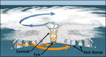
The eye is the center of the storm, typically containing calm winds, sinking air, and clear skies and is normally 15-30 km in diameter (~10-20 miles). The formation of the eye is a curious process. Since hurricanes are Low pressure systems, the air around them spirals inward toward the lowest pressure (fluid always moves from high pressure to low pressure). This would suggest the center is also where the most intense convection would occur, and in the early stages of growth, that's true. But it's in those early stages where the central deep convection forms what's called a "warm core" aloft; the continuous release of latent heat through condensation actually raises the air temperature in the mid-upper levels by several degrees. Then, through a process we won't discuss here (thermal wind balance), the low-level winds respond by speeding up. An outward-pointing centrifugal force comparable to the inward-pointing pressure gradient force that already existed begins to pull the convection and moisture out from the center. The distance from the center of the Low at which these forces come into balance determines the size of the eye and eyewall.

The eyewall is the ring of deep convection surrounding the eye. It's characterized by the strongest updrafts, the highest/coldest cloud tops, the most violent winds, and is truly the powerhouse of the entire hurricane. A hurricane's strength is gauged by the lowest pressure in the eye and by the highest winds in the eyewall, and it's the eyewall that is feared most during landfall.

Another notable feature that forms early during development are the spiral bands. Also called rainbands, feeder bands, etc, these are the long arms that can extend many hundreds (or even a thousand) of kilometers away from the center of the storm (most storms aren't bigger than 800 km or 500 miles across). Although the reason for their formation is too complicated for the scope of this article, they are still an important part of the storm. The strength, size, and number of bands can affect the intensity of the eyewall either positively or negatively. They can buffer the eyewall from a more hostile environment outside the storm, or they can rob valuable inflow to feed their own convection.


So, the eyewall and spiral rainbands are convective (containing active updrafts). They are all rotating counterclockwise (cyclonically) around the central Low. Surface air is being pulled inward to the center of the storm, then upward through the eyewall, then outward through the exhaust (IN-UP-OUT). Interestingly, the exhaust above the storm rotates anticyclonically as it moves out (remember how the Coriolis effect makes air rotate clockwise around a High?). Therefore, the areas of warm moist inflow (low-mid levels) rotate cyclonically while a drier cold shallow layer (uppermost levels) rotates anticyclonically.


Intensity & Dissipation

Nearly all of the factors that control development also control the mature storm's intensity. But there are important phases of a tropical cyclone's evolution that will be discussed. The first part, the incipient disturbance or "tropical wave", is just a cluster of thunderstorms, sometimes small, sometimes very large, but disorganized nonetheless. There is little or no circulation associated with it, and the surface pressure may not be much different than that of the surrounding environment.


The next phase is where the National Hurricane Center (NHC) steps in with formal advisories and public bulletins: the Tropical Depression. At this point, a Low pressure has developed and therefore a closed circulation. Although the winds are still weak (less than 17 m/s or 40 mph), a TD is characterized by persistent deep convection and a surface Low perhaps a few millibars less than the ambient pressure. There are typically 12-13 TDs that form during the six-month Hurricane Season.


Further organization yields a Tropical Storm. At this point the convection is still persistent, the CDO is typically large, solid, and quite cold, the central surface pressure might be 5-10 millibars below the ambient pressure, and the winds must be at least 17 m/s (40 mph), but not greater than 32 m/s (74 mph). If the TS threatens land, the NHC will issue Tropical Storm Advisories, Watches, and/or Warnings based on proximity and likelihood of impact. About 10 of the 12-13 Depressions achieve Tropical Storm status in an average season.


As the warm core aloft increases in magnitude due to concentrated latent heat release in the core of the Low, the surface pressure drops further and the winds wrapping around the Low respond by increasing. A hurricane is born when winds reach 32 m/s (74 mph) and the surface pressure, or minimum sea-level pressure (MSLP) as it's referred to, is at or below approximately 990 mb, or 10-15 millibars below ambient pressure. Similar to the TS, Hurricane Advisories, Watches, and/or Warnings will be issued by the NHC if the storm threatens land, and High Seas Bulletins alert the shipping industry. Typically only 6 hurricanes form each year, or about half of the number of Depressions make it to this stage.


Although a hurricane is the last phase of maturation in a tropical cyclone, a special name is given to those that reach wind speeds of 48 m/s (111 mph). A major (or intense) hurricane is a very rare storm that has reached a remarkable level of organization. The environmental influences must be nearly ideal for this to occur, such as little or no vertical wind shear, very warm sea surface temperatures, etc. In these storms, the MSLP might be 50-110 millibars below the ambient pressure. It's important to note that intensity is independent of size... stronger hurricanes are not necessarily larger; in fact, the opposite can be true. In an average season, only 2-3 of these mega-storms form.


There is a scale to define the large range of intensities that hurricanes can attain. The Saffir-Simpson Scale was devised in 1969 by Robert Simpson and Herbert Saffir to provide scientists and emergency management personnel a way to objectively describe the intensity of a storm based primarily on maximum winds, but also on minimum sea-level pressure, storm surge depth, and potential magnitude of damage upon landfall (see http://www.aoml.noaa.gov/general/lib/laescae.html). The scale is presented here with information on wind speed, storm surge, MSLP, and damage potential:

CATEGORY MAX SUSTAINED SFC WINDS
[in kts (mph)]
STORM SURGE
[in m (ft)]
MSLP
[in mb ("Hg)]
Tropical Depression <35 (<40) - -
Tropical Storm 35-63 (40-73) - -
CAT 1 64-82 (74-95) 1.2-1.5 (4-5) >980 (>28.94)
Damage primarily to shrubbery, trees, foliage, and unanchored mobile homes. No real damage to other structures. Some damage to poorly constructed signs. Low-lying coastal roads inundated, minor pier damage, some small craft in exposed anchorages torn from moorings.
CAT 2 83-95 (96-110) 1.8-2.4 (6-8) 965-979 (28.50-28.91)
Considerable damage to shrubbery and tree foliage, some trees blown down. Major damage to exposed mobile homes. Extensive damage to poorly constructed signs. Some damage to roofing materials of buildings; some window and door damage. No major damage to buildings. Coastal roads and low-lying escape routes inland cut by rising water 2-4 hours before arrival of hurricane center. Considerable damage to piers. Marinas flooded. Small craft in unprotected anchorages torn from moorings. Evacuation of some shoreline residences and low-lying island areas required.
CAT 3 96-113 (111-130) 2.7-3.7 (9-12) 945-964 (27.91-28.47)
Foliage torn from trees, large trees blown down. Practically all poorly constructed signs blown down. Some damage to roofing materials of buildings; some window and door damage. Some structural damage to small buildings. Serious flooding at coast and many smaller structures near coast destroyed; larger structures near coast damaged by battering waves and floating debris. Low-lying escape routes inland cut by rising water 3-5 hours before hurricane center arrives. Flat terrain 5 feet or less above sea level flooded inland 8 miles or more. Evacuation of low-lying residences within several blocks of shoreline possibly required.
CAT 4 114-134 (131-154) 4.0-5.5 (13-18) 920-944 (27.17-27.88)
Shrubs and trees blown down, all signs down. Extensive damage to roofing materials, windows, and doors. Complete failure of roofs on many small residences. Complete destruction of mobile homes. Flat terrain 10 feet or less above sea level flooded inland as far as 6 miles. Major damage to lower floors of structures near shore due to flooding and battering by waves and floating debris. Low-lying escape routes inland cut by rising water 3-5 hours before hurricane center arrives. Major erosion of beaches. Massive evacuation of all residences within 500 yards of shore possibly required, and of single-story residences on low ground within 2 miles of shore.
CAT 5 >134 (>154) >5.5 (>18) <920 (<27.16)
Shrubs and trees blown down, considerable damage to roofs and buildings; all signs down. Very severe and extensive damage to windows and doors. Complete failure of roofs on many residences and industrial buildings. Extensive shattering of glass in windows and doors. Some complete building failures. Small buildings overturned or blown away. Complete destruction of mobile homes. Major damage to lower floors of all structures less than 15 feet above sea level within 500 yards of shore. Low-lying escape routes inland cut by rising water 3-5 hours before hurricane center arrives. Massive evacuation of residential areas on low ground within 5-10 miles of shore possibly required.


Hurricanes don't last long though, typically a couple of days to as long as a couple of weeks, depending on track and environmental influences. A slow-moving hurricane may linger too long over one spot and stir up the colder water from below (this is called "upwelling") causing its demise. Moving too quickly can also destroy organization. Moving over cold water (colder than 26°C or 79°F) will gradually weaken a storm because the moisture source is reduced. Moving over land will very rapidly dissipate a storm because the moisture source is gone and friction with the land acts to spin down the winds, allowing the central Low to "fill".


Track

Equally important as the intensity is the track, and perhaps more so, as the track can have an immense influence on the intensity. Atlantic hurricanes can originate in several places: Gulf of Mexico, Caribbean Sea, off the U.S. eastern seaboard, in the central part of the basin, or off the coast of Africa. Certain areas are favored in different parts of the season as the atmosphere changes; wind patterns shift, the ocean heats and cools, and the frequency of mid-latitude troughs or easterly waves change. Normally, the Gulf and Caribbean dominate formation in the first part of the season, then Africa provides the activity in the middle part of the season (these are called Cape Verde storms, because they form near the Cape Verde Islands of Africa's west coast), then mid-latitude troughs exiting the U.S. mainland can generate storms on the trailing edge of fronts toward the end of the season... of course, there are exceptions.

Hurricane tracks are dominated by four mechanisms: the Earth's sphericity, the tropical easterlies, the mid-latitude westerlies, and synoptic-scale High or Low pressure systems. They all work together in varying degrees and are always present.

Storms in the deep tropics move west-northwest due to the sphericity of the Earth alone; this is called the beta-effect (related to the increase of Coriolis effect with increasing latitude). It explains why storms drift WNW in the tropics even in the absence of significant atmospheric forcing. Between the equator and about 30N, the steering winds are easterly, pushing storms to the west. Then above about 30N, the steering winds become westerly, pushing storms to the east. Where these flow regimes meet, hurricanes "recurve" (they go from traveling northwest to northeast). The last major factor in the track of a storm is synoptic-scale Highs and Lows, the ones we see on the weather maps. One of the more persistent Highs is located in the north-central Atlantic, called the Bermuda High. Then there are the troughs and associated fronts that sweep across the basin from the mainland U.S. These act to push the hurricanes northeastward and then eastward, curving them away from the mainland. The shear associated with these fronts is also quite strong, several times stronger than hurricanes can tolerate, so they tend to lose their characteristic features and/or transition to extratropical cyclones.

The steering winds for a given storm actually depend somewhat on the intensity of the storm itself! Very weak storms are largely affected by the low-level winds, between about 850mb to 700mb. Then the stronger the storm becomes, the deeper the layer responsible for steering. For the strongest of storms, such as major hurricanes, the deep-layer mean flow (700 mb up to about 200 mb) becomes more important for steering the vortex. The reason for this is that weak storms have only modest deep thunderstorm activity, so the mass (water) is mostly located in the lower levels. As the storm strengthens, the deep convection puts more mass (water) into the middle and upper levels, so in order to steer the entire system, winds at those levels become more important.

A very minute yet fascinating topic in tracks is something called "cycloidal oscillations". These are little deviations from the main track, usually no larger than 30 km (~20 miles) in the cross-track direction; i.e., the wobbles are about as big as the eye itself. Hurricane Juliette in the East Pacific (9/25/2001) exhibited a clear case of cycloidal oscillations (see animation at http://einstein.atmos.colostate.edu/~mcnoldy/tropics/juliette/268/javajuliette268.htm ; it helps to speed up the loop once it's loaded). These oscillations are seemingly caused by convective asymmetries and other chaotic forcings and also seem to mostly affect very well-organized hurricanes. Cycloidal oscillations are merely an interesting facet of hurricane tracks, they play little role in intensity change or even track forecasting.


MESO, June 2002

http://www.mcwar.org


Home page